I use a Garmin GPSmap 76S unit for air navigation, using Rory's free airspace map.
This map shows controlled airspace within the UK, as depicted on the CAA's Half-mil air charts.
I wanted more information on my GPS when I fly so I have created extra Garmin air maps.
Each map can be used stand-alone or together with the 'Rory' Airspace map (available free on the internet).
DOWNLOAD MAPS HERE
UK HILLS & TERRAIN (248kb) Hills and Mountain Ranges in colour, as per the 1:500,000 chart
UK ROADS & TOWNS (284kb) Roads, Towns & Villages with names as per the 1:500,000 chart
UK COAST OUTLINE (100kb) A fast, simple outline of the British coast to 'contain' these maps
What to do...
Download and double-click each archive file to extract to your 'My Documents' folder.
The information on this page is also in the 'ReadMe.txt' document found in each archive file.
The accuracy of the maps is best as I could get using CAA charts and OziExplorer. I offer them free to use at own risk.
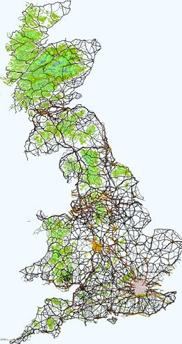
The maps will look like this when used together.
MORE DETAILS...
The maps cover mainland Britain only (plus the Isle of Wight) and both are split into two files: Northern UK and Southern UK. This is to keep the size of GPS files low and so speed up GPS operation.
HILLS & TERRAIN MAP: This map shows coloured polygons for mountain ranges and noticable hills within mainland Britain. I used three different colours/shades to represent a peak. These represent 500ft, 1000ft and 1500ft in lowlands, and 1000ft, 1500ft and 2000ft in highland areas with the highest summits displayed by a contour polyline. Spot-heights are shown too.
The idea behind this is to display those visible hills and summits we can fly from or fly into. Just about all our terrain is above sea-level but this map only displays actual peaked terrain.
ROADS & TOWNS MAP: This map gives all 'A' and 'B' roads and some minor roads that feed the hills and mountains. Roads are mostly labeled with their A or B numbers. Towns are shown as polygon shapes with names. Villages are mostly there but not all have names. (Although the Garmin gpsmap 76C colour unit has roads as part of the basemap this map shows roads and towns as per the CAA map.)
Hopefully these two extra maps will give the GPS a more CAA half-mil feel than when using an Airspace-only display.
I use a Garmin GPSmap 76S. It has monochrome display and I chose the colours so that they look OK in colour or B&W.
The maps were designed purely for air use and as such are not accurate enough for use when driving or hill-walking.
UPLOADING MAPS TO YOUR GPS (via a PC)
The map are .IMG files. This is the binary format that Garmin units require. There are several things to know to upload maps to your Garmin GPS.
When you upload a map to a Garmin GPS it will delete all maps that are currently on your GPS first. This means that you must upload ALL the maps you want on your GPS, every time you upload any new map. SO... make sure all the various GPS maps you want to use are available on CD or your hard disk because you cannot download a map from the GPS unit.
If you don't have the original IMG map files on CD then you will lose them from your GPS unit if you try to upload new maps. It's just that crazy Garmin way I guess!
Upload maps using the MapSource software that comes on the map CDs you own. If you don't have such a disk then you will need to download 'IMG2GPS', a free program found on the internet.
1 - Connect your Garmin GPS to the PC with the cable.
2 - Copy all the IMG maps you wish to upload to a new folder (i.e. C:\GARMIN\UPLOADS). Maps with a '.IMG' file extension.
3 - Install IMG2GPS and run it.
4 - Click the LOAD FOLDER button and find your upload folder with the IMG maps.
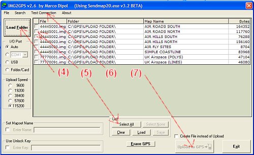
5 - Select all of the maps in it that you wish to upload by clicking the SELECT ALL button, or each map's checkbox.
6 - Check the GPS-PC connection by choosing option: TEST CONNECTION
7 - If connection is OK a message will tell you so. Click it to remove it and click UPLOAD TO GPS button to upload the maps to the GPS.
PROBLEMS UPLOADING MAPS
SERIAL CONNECTION
Sometimes I have found that the program says 'maps uploaded successfully' but they didn't. If this happens check the cable connection again and test the connectivity. Then try uploading once more.
If problems persist try clicking the ERASE GPS button first, then upload the maps. Or, try setting a slower upload speed by selecting a lower baud rate from the 'UPLOAD SPEED' radio-buttons. It should upload at the fastest rate of 115,200 normally but try a lower value.
USB CONNECTION
Check the GPS-PC connection by choosing option: TEST CONNECTION. If this doesn't connect to your GPS you should download an updated usb driver from the Garmin website's 'downloads' page. After you 'install' the new usb driver check it has 'taken' by going to Control Panel/System/Hardware and looking for the Garmin USB entry. If it has not entered itself properly the entry will have a '!' next to it. Open the properties for it and choose to upgrade the driver. Find the downloaded upgrade on your hard disk and select it manually.
Good luck!