GETTING AWAY XC FROM WESTBURY
Westbury has excellent thermals but he'grab-a-thermal-and-go-downwind' XC method is not possible
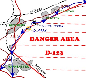
Directly behind the slope to the south are the Salisbury Ranges. We have to go around these danger areas to get away.
There are two XC directions from the White Horse: South and East...
Blue arrows show zone-skimming XC routes
GOING SOUTH (Northerly Winds)
When the wind is North we fly from Westbury's north slope. Get as much altitude from a good thermal before it tracks too far south into the Danger Area. It is best to leave the thermal over or a little south of the chalk pit and head west a touch to avoid the western point of the danger area. Exactly where the danger area crosses the chalk quarry is shown in photo 1. Notice that the danger area boundary bisects the chalk pit and follows the small ridges to the southwest.
Once over the chalk quarry you should turn SouthWest toward Upton Scudamore village. The danger area ends at the intersection of the village and the A350 main road. Once you reach this point you are clear of D-123 and can head south or southwest as requred.
Meanwhile your first thermal is still tracking south, a little to your left. If the wind is has some east in it (i.e. if it is NNE or NE) you may be able to catch it again by using speedbar, especially if it is a big thermal.
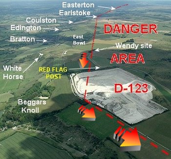
Photo 1. Turn southwest at corner of quarry
Warminster is a good thermal source. In a North wind you will head toward Blandford Forum from here. When the wind is more easterly you will head over Longleat Park and Mere flying hill but watch for sailplanes just prior to Mere. It finally heads you toward Dorchester.
It is possible to reach the coast in both North, and NE winds. though when heading dead south beware of the airspace west of Bournemouth Airport.
GOING EAST (Westerly Winds but not NW)
The easiest XC route is flown in a West or WNW wind. Get a good thermal and go with it east as far as the danger zone allows. You can track a thermal as far back as just south of the East Bowl area before you have to turn a little left to stay out of the danger area. Then head toward Edington village for the next one.
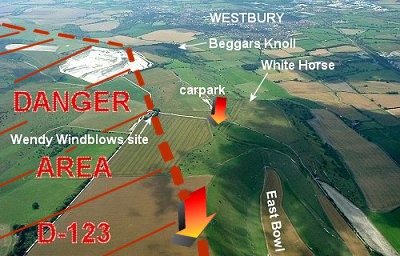
Photo 2. Follow thermal to just south of East Bowl and head to Edington
Now look downwind (east or north east) for the next ride (a building cumulus).
(In some skies you may choose to head back toward the slope or the works chimney smoke for another thermal. Don't go too far west though, you just want a good cloud-base thermal for the next ten kilometers.)
Follow the B3098 road East past the golf course keeping just north of the prison, all the way east along the Pewsey Vale.
Once you have passed south of Devizes you are in the Vale of Pewsey. This is a bit of a sink-hole. I've been at base here and found nothing all the way down to the ground.
If you do get to south of Pewsey the Upavon Army Airfield is easily visible up ahead as a large white hanger on a hill. This should be passed to the north as it is in the zone. Caution: gliders fly in this area at weekends.
Note that both Pewsey and Andover have railway stations making it much easier to get back to the hill.